Thursday, July 3, 2014

DAY 6 - LOUGH INAGH TO LEENANE

The day dawned looking much more promising than the day before and we set out for the next leg of the walk to the village of Leenane on Killary Fjord.   

You can see a larger version of any photograph by simply clicking the mouse once on the image. Another click outside the image returns you to the text   
 

The view from Lough Inagh Ranch B and B across Lough Inagh to the Twelve Bens

The first half of the walk was essentially flat across open country and then into a forest.  We started out before the German couple but it was no surprise to us that they eventually caught us up and disappeared up the track ahead of us and into the forest.

Our parting of the ways with the young couple

Coming out of the forest

Our first view of Killary Fjord

There were always plenty of sheep on the path

The Village of Leenane,

The little harbour at Leenane


Our Leenane B and B


Leenane was to be our resting place for three nights. We had by this time walked for five consecutive days and covered 72 kilometres and we decided when setting up the walk to take one walking day off here.  That was the beauty of the system set up by Hillwalk as the whole thing was extremely flexible.
DAY 7 - LEENANE

In the morning we took a boat trip up Killary Fjord.  KiIlary claims to have the only fjord in Ireland although Wikipedia adds Carlingford Lough and Lough Swilly. The dock for the ferry was about 2 kilometres down the road and left in plenty of time to be sure to get on.  A coach tour arrived so they had quite a good load on board.  The trip takes about one and a half hours and reaches the entrance on the Atlantic Ocean.  
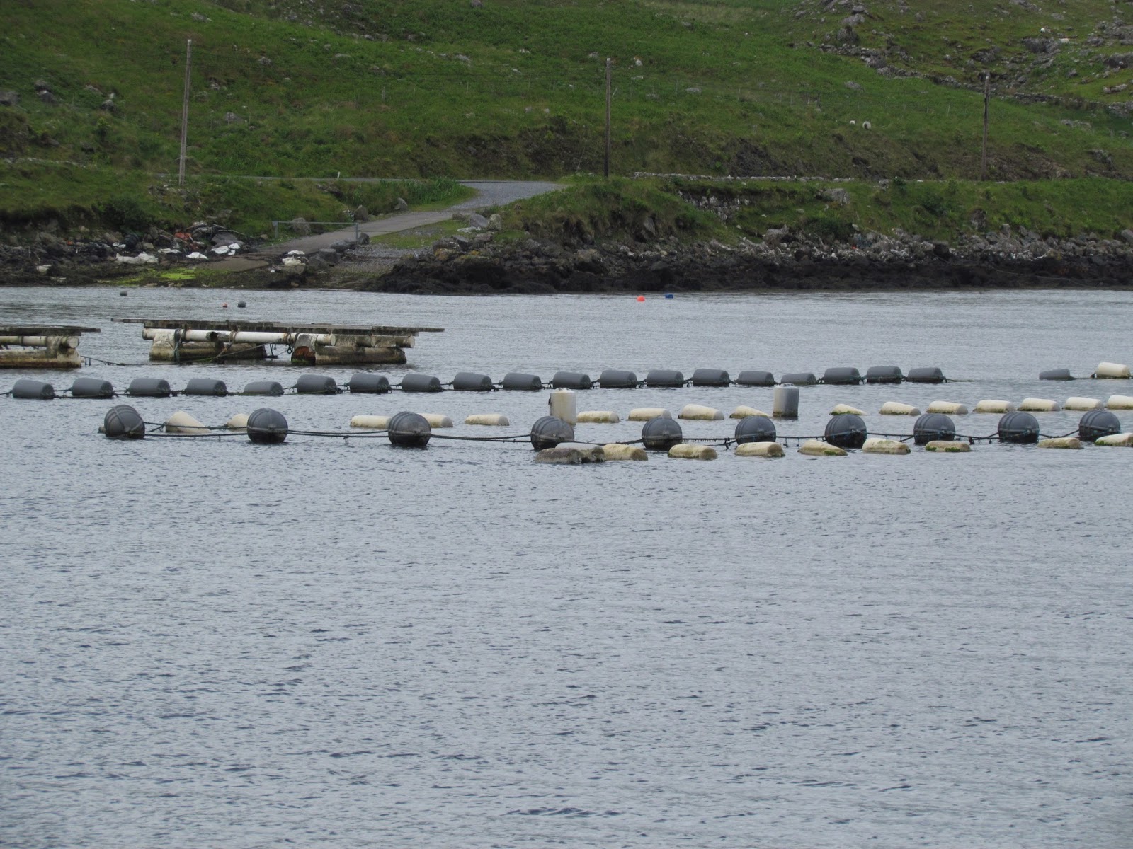
Aquaculture has become a big industry in recent years and we passed a very large number of buoys to which are attached long ropes on which mussels grow.  It takes about one and a half years for the mussels to become fully grown as food.  The buoys are all strung together in long lines.  Mussels were always on the local menu.  There is also a farmed salmon industry where they start the salmon off in fresh water lakes and transfer them into circular pens near the entrance to the harbour.


You can see a larger version of any photograph by simply clicking the mouse once on the image. Another click outside the image returns you to the text  


Close up of the buoys

Harvesting the mussels
After the trip we walked back into the village and visited the Sheep and Wool Centre.  This consists of a shop, a cafe and a small museum.  The museum had an active sheep farmer present to tell us all wanted to know about the local industry.  It was a pity that very few took the opportunity to come into the museum as outside there were always plenty of visitors.  We learned about the over twenty varieties of sheep in the region although the most common by far was the Scottish Black Face and we saw lots of those on our travels.  We learned the difference between wool and worsted.

In a Nutshell: "Woolen", basically means that the individual fibers of varying lengths are going in many different directions, overlapping each other at a variety of angles and leaving air spaces between the individual fibres. To achieve this the wool is carded with a comb and then rolled up into a cylinder and the wool is pulled out of the cylinder and spun. "Worsted" means that the individual fibers are roughly the same length and are running parallel to each other and only overlapping at the tips, leaving little to no space between the individual fibres and then spun pulling fibres from the end.

We also saw a  number of examples of knitting patterns and we had seen some of these on Inishmore which is known for its rugged chunky sweaters.

Examples of knitting styles

The VIllage of Leenane. 
In this photo there is a pub called The Field recognising that a film of the same name we shot in Leenane some years ago.  The lead actors were Richard Harris and John Hurt.  When we got back to the B and B there were a set of cases and bags waiting for their owners.  This was a group of five men who were on a walking holiday following the route were were walking with Hillwalk.  Four were from Belgium and one from France.  They were one day behind at this point.
DAY 8 - KILLARY HARBOUR AND THE FAMINE ROAD
In 1960 we spent a vacation in Ireland.  We took the train (steam) from Dublin to Galway and hitched our way around the West reaching the Youth Hostel at Rosroe at Killary Harbour.  It seemed natural to revisIt fifty four years later.  As part of the Hill Walk Western Way walk there was an optional extra day walking from KiIlary Harbour along the Famine road to Leenane which was not actually a part of the Western Way.  

You can see a larger version of any photograph by simply clicking the mouse once on the image. Another click outside the image returns you to the text  

Wittgenstein's cottage in front of the old hostel building


We had walked in from the road all those years ago but as an arranged part of our walk a taxi took us out to Rosroe and we walked back to Leenane.  The hostel building was still there but it had fallen a little into disrepair.  A notice said it was under renovation but that looked to be a doubtful claim.  Part of the building was a modest house which was used by Ludwig Wittgenstein, the famous philosopher, as a quiet place to write shortly after World War II. A plaque to this effect was unveiled by President Mary Robinson in 1993.

Our walk took us back to Leenane along the Famine Road.  This was a make-work project in the mid 1800's  at the time of the Great Famine when the potato crop failed.  There was considerable emmigration from Ireland as a result of this catastrophe.  The road runs along the South shore of Killary Harbour to the main road half way to Leenane.  This road dates from about 1850.  At the time it was considered wrong to simply give charity to people and for that reason roads like the Famine Road were constructed to provide employment to starving farm labourers in return for food.

The entrance to the Fjord at Rosroe
Not much of a road


Wild goats

An old run down cottage with a magnificent rhododendron bush (tree?)

This is the site of village of Fohar
Fohar was a small settlement that was abandoned at the time of the Great Famine.  There are roofless builidngs and old potato cultivation ridges evident.

We remember seeing Fuchsia the last time we were here

The Rhododendrons seemed new to us and they are apparently a plague for the farmers as they spread around

Still a rough track at this point


One of the dilapidated buildings

A cool running stream

The track connected to the path we had used on our walk from Lough Inagh to Leenane

Looking back along Killary Fjord to Rosroe, the scene of the boat trip

We joined up with the track into Leenane and were nearly home (by 50 metres) when the heavens opened and we had to take cover as best we could, a wet end to a lovely walk.  We sheltered near the Leenane Hotel, more swanky that Port Finn and it boasted a seaweed bath.  We hadn't seen a bath for many days as all the B and B's have showers.  We decided that perhaps a seaweed bath was just what the doctor ordered so we came back to spend an hour in simple luxury.  You start off in a very hot steam room for about ten minutes and then you move into another room with two large china baths,  They are filled with very hot water in which is soaking seaweed gather that day from the coast.  You add cold water until you think you can stand the temperature and you get into the somewhat unappetizing lookiong water.  You stay there for part of the hour and when you are ready you pull on a string to release forty seconds of cold water. Ugh!

Our European hiking group didn't do the Famine Road walk so they were now ahead of us.  We were to meet up with them once more.
DAY 9 - LEENANE TO DRUMMIN

The next leg on the Western way was a really beautiful walk.  It took us first along the Erriff River Valley and then up and over some hills into an area in the vicinity of Croagh Patrick.  This walk was another one where "gentle" gave us an advantage as we were to phone ahead to ensure that we would be picked up and taken to the B and B and it also allowed us to order an evening meal in a region with no other easy opportunity to eat.

You can see a larger version of any photograph by simply clicking the mouse once on the image. Another click outside the image returns you to the text  

The walk had us on two different maps and you need three parts to follow the route
Leenane to Aasleagh Falls and beyond plus two short sections at the top right hand corner of the map
The section from Houston's Bridge to Drummin
Drummin to the B and B
Our taxi man from the previous day took us a few kilometres down the road to Aasleagh Falls which was the start for the day's walk.  This reduced the day's walk to a more manageable 17 kilometres. 

At the start of the day with Aasleagh Falls in the background

Aasleagh Falls
Downstream on the River Erriff


A smaller falls en route

The River Erriff

The river, the mountains and more rhododendrons

We walked by the river all the way to Houston's Bridge and the map 1 above is inaccurate as it shows the Western Way on the road.  The real Western Way was so much nicer.  Just before we left the river valley we ran into a brief rain storm notwithstanding the cloudy blue skies in the photos.  Leaving the valley we climbed up and into a forest and there we had a lunch break and it rained quite heavily again for a while.  However, it was a changeable day and we were soon dry again.  It was on this leg that we came across a very nice Nike hat.  It turned out that it belonged to one of the European group and we were fortunately able to re-unite with with the owner at the end of our journey. We climbed up a long drawn out hill to be greeted at the top with a splendid view along a new valley and journey's end was somewhere out there according to the map.

The view at the top of the climb
Every good climb up deserves a hill down and we descended into the valley floor at Barnaderg.

Downhill to Barnaderg
The last leg wasn't particularly interesting, just along the road to Drummin where we were to stop our walk for the day at Breslin's pub. We made our phone call to the B and B .  Unfortunately the pub was closed!

Breslin's pub - closed on our arrival

The B and B owner collected us for the 5 or so kilometres left and she took us down the road to Moher House B and B where we again we were given a cup of tea and, this time, a jam scone.  It had been a really nice day.

Moher House B and B


The beautiful garden at the B and B
We enjoyed our meal which ended with an Irish coffee and a Bailey's coffee on the house!  We also heard that the wiry Albertan had also stayed at Moher House on his way through and was currently staying with the sister of the B and B owner further up the Western Way.
DAY 10 - DRUMMIN TO WESTPORT
Our last day took us to journey's end, the town of Westport.  We needed two maps again.

You can see a larger version of any photograph by simply clicking the mouse once on the image. Another click outside the image returns you to the text  

The start of the day's walk
The route to the town of Westport at the end of the walk
Our walk didn't pick up where we left off at Breslin's pub but we were driven to the Western Way in the shadow of Croagh Patrick.  Our walk was just 10 kilometres, an easy prospect after some of the other days. Croagh Patrick loomed above us and the photograph shows the track to the summit.  It is the site of Christian pilgrimage associated with Saint Patrick who reputedly fasted on the summit for forty days in the fifth century A.D. Thousands of people climb the mountain every Reek Sunday which is the last Sunday in July.  The climb was not part of our itinerary.


The track to the summit of Croagh Patrick

The rough track at the start of the day


Over the top and the view of Clew Bay
A few cows for a change in the outskirts of Westport
And here we entered Westport
One of the recommended eating places but it was too far out of Westport for walkers
Our last view of Croagh Patrick
An Insect Hotel
Our path took us from the Westport Quay on Clew Bay along a path to the town centre passing the insect hotel.  It followed the route of an old railway line from the harbour quay to the current station.

The last waymarker on the Western Way - we had reached our objective


We walked down to the clock tower and out to the last B and B
The Altamount B and B Westport
It was a bit of an anticlimax as the owner wasn't at home but we had arrived quite early in the afternoon as the day's walk was relatively short.  She arrived back home and we were warmly welcomed and re-united with our back pack.  This time we were given a cup of tea and a slice of barmbrack (a kind of fruit bread).

Our European fellow walkers had arrived safely the day before and they had spent the day riding bikes on another converted railway track from the coast near Achill Island and they were returning home the next day as well.


A charming view in Westport

The final short section of the walk on the Western Way can be found by clicking on "Older Post" below right.

Wednesday, July 2, 2014

WESTPORT TO DUBLIN AND HOME

We took the morning train from Westport to Dublin, collected our case from the B and B where we had left it and made our way to Dublin Airport from where we were flying to London Gatwick.  The other walkers took a taxi all the way to Dublin Airport!  We stayed overnight at the Gatwick Yotel which we had used once before.  The hotel is right inside the terminal and convenient to check in early the next morning.  The room isn't large but it is clean and extremely well appointed with a great bathroom.

We flew back direct to Vancouver and then into Comox, a very easy journey. 

It all worked out well and we were pleased to have covered about 120 kilometres on the walk in really beautiful country.  Hillwalk was an extremely efficient organization and their planning was perfect.  Highly recommended.